Internet resources: NASA unveils accurate map of Mars on Internet
The National Aeronautics and Space Administration (NASA) made a real present to all astronomy buffs: on Friday the department unveiled a virtual map of Mars, completed by Mars Odyssey spacecraft.
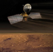
The map was put together from images from a camera that takes "pictures" by using infrared measurements of temperatures, called the Thermal Emission Imaging System (THEMIS), aboard NASA’s Mars Odyssey spacecraft, which has already compiled close to 21,000 images of the planet. Based on these images NASA engineers have constructed an accurate global map Mars.
The map is reported to be completed by NASA jointly with researchers of the Arizona State University and is today available on university’s servers. NASA informs that THEMIS was launched 8 years ago and since then Mars Odyssey has been transmitting data to the NASA's Jet Propulsion Laboratory in California.
The released map is considered to be the most accurate out of those available to public. The images were smoothed, matched, blended and mapped to create a giant mosaic of the planet. The map allows users to see the entire surface of the planet and zoom in as close enough so that the smallest surface details are 330 feet (100 meters) wide. Researchers claim that more detailed maps of Mars are available, but firstly, they don’t cover the entire surface of the planet, and secondly, they can be accessed by professional astronomers only.
In the near future NASA is planning to expand the scope of its project “Be a Martian”, which will enable all the amateur astronomers to submit their data related to Mars observation to NASA.