History of Russia: Exhibition of unique geographical maps of Russia opened in Moscow
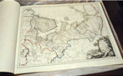
The All-Russian Museum of Decorative and Applied Arts in Moscow hosted an exhibition "Rossika: a collection of maps of the Russian Geographical Society". More than 70 unique maps of the XIV-XIX centuries from the private collection of Alisher Usmanov, donated to the Russian Geographical Society are on display for the first time to the public.
The presentation was attended by the head Russian Ministry of Defense, the President of the Russian Geographical Society Sergei Shoigu.
The exhibition features 77 maps of the XVI - XIX centuries from the collection of the RGS. Thematically, the exhibition is divided into three parts. Here are maps of the time of Ivan the Terrible, the Time of Troubles and the beginning of the Romanov dynasty. Another part reflects the times of Peter the Great, the Northern War, the foundation of St. Petersburg, as well as studies in Siberia. The third part - the maps showing the lands of ancient ideas about the future of Russia. All maps are made by European cartographers based on various sources - ancient Russian drawings, data merchants and travelers, the heritage of ancient authors. Totally, this collection includes more than 500 maps.
Sergei Shoigu told about the plans for the restoration of the RGS and the publication of various historical materials. He noted that the RGS annually provides grants to organize expeditions to study the history and culture of Russia, and every year the amount of these grants is greatly increasing.