Electronic libraries: Electronic Library of the Russian Geographical Society has been enriched with map collection
The electronic library of the Russian Geographical Society has a new section "Map collection". The first map presented here is a collection of "Rossika", presented by the Russian Geographical Society in 2013 by a member of the Board of Trustees of the Company, businessman and philanthropist Alisher Usmanov.
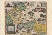
The term "Rossika" experts call that was produced abroad about our country. In this case, we are talking about Russian maps made by foreign masters-cartographers. The term is used not only for maps but also books, paintings.
In autumn 2013, more than 70 unique maps from this collection were first exhibited to the public at the Russian Museum of arts and crafts at the "Rossika: collection of maps of the Russian Geographical Society". Today in the open access is coming almost 500 maps of Russia of the XV-XIX centuries, made by foreign writers, including such famous artists as Abraham Ortelius (1512-1594), Gerardus Mercator (1512-1594) and others.
The main content of the Ordnance Survey RGS Foundation presents works directly related to the Company's activities and its members. These are expedition manuscripts, printed works and fundamental associated with the study of Russian in the XIX century.
Cartographic materials of the Russian Geographical Society became available to the general public for the first time in 30 years. This was made possible thanks to the reconstruction of cartographic division, which started work on the study and systematization of this rich collection.
Among the submissions are particularly interesting maps of the XV-XVI centuries, as the Russian "blueprints" of that time have not survived, but their existence has a lot of evidence.
Maps of Russia, published in XVIII-XIX centuries, are more detail and precision as through the development of cartography in general, and because of the publication of the first Atlas of the Russian Empire in 1745. Copies of the atlas, published in Latin, German and French, were in Europe and were used by many cartographers.
European maps of this period exist in other major funds in the country. However, the collection of the Russian Geographical Society favorably differs from them that is devoted exclusively to Russia at different times and can give a visual representation of the change in our country and its study. The presented collection the richest historical and geographical material.