Internet and history: On Geo portal of the Russian Geographical Society is published "Map of the country of the Golden Fleece"
On the Geo portal of the Russian Geographical Society is published a Map of the Caucasus with the surrounding parts of Turkey and Persia. The first sheets of this map were first published in 1869 in Tiflis (Tbilisi, Georgia). In its preparation an active involvement came from the Caucasus Military Topographic Department and the Caucasus department of the Imperial Russian Geographical Society.
Map was reprinted several times and supplemented with new sheets, and in the period from 1902 to 1914 it was completely corrected. In 1921-1922 were held phototheodolite works on the Georgian Military Highway and other regions of the Caucasus. The data were subsequently used to update maps and subsequent reissues of sheets.
Late publication sheets are supplemented with metric scale and pointer corresponds to the height in feet to meters, which is associated with the transition to the metric system of units. Legend to the map was printed in sheets, since the 1920s, there are explanations only to the lines of communication - show the different types of railway, postal and pack the roads.
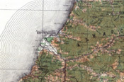
Map of the Caucasus with the surrounding parts of Turkey and Persia - one of the most famous maps of the southern part of the Russian Empire. The quality and accuracy of its preparation allowed republishing it for almost 70 years from the date of the first sheet. Currently, it carries valuable information on the state of the region at the beginning of the XX century, which may allow tracing the dynamics of its development.