The study of South Sakhalin under the leadership of Lieutenant Nikolai Vasilyevich Rudanovsky
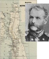
One of the most significant events in the history of Sakhalin is the activity of the Amur expedition of 1849–1855 under the leadership of G. I. Nevelsky. The opening of the navigability of the mouth of the Amur and the Nevelsky Strait, the foundation of new Russian settlements, the beginning of the development of the island’s natural wealth, the study of its nature and the indigenous population are associated with it. A striking episode in the work of the Amur Expedition was the establishment of the Muravyovsk military post in the Aniva Bay. In the instructions left to the post officers, Nevelskoy wrote: “To Lieutenant Rudanovsky, according to my personal order, with the onset of the winter route, to survey the shores of Aniva Bay, which Orlov did not have time to inspect, as well as to make an inventory of the western coast of Sakhalin from Cape Krlion to the village of Kusunai. To survey the significant rivers that irrigate the southern part of Sakhalin and the paths leading to the north”. In pursuance of the instruction of 250 days spent on Sakhalin, N. V. Rudanovsky spent 140 days traveling around the island.
Rudanovsky made 5 expeditions. The first expedition began on October 6 (18), the last - on March 4 (16), 1854. Using imperfect devices - a pel-compass, sextant, an artificial horizon and a thermometer, Rudanovsky examined the Sakhalin space between the 46th and 48th parallels, passed on dogs, kayaks and on foot over 500 miles. He was the first exploratory traveler to describe in detail not only the coastline of Middle and South Sakhalin, but also some inland areas. The map of South Sakhalin compiled by him was the first map of this region, which, thanks to its detailed data, did not undergo any changes for more than half a century. Rudanovsky's materials were used in the first printed works on Sakhalin and the Far East. According to the original map of Rudanovsky, the Hydrographic Department published the “Map of the middle part of Sakhalin Island from Cape Otas to the north to Cape Voronin” and “Map of the southern part of Sakhalin Island from Cape Krilion to the parallel of Orokes Bay”. Meteorological observations were included in the “Essay on the physical geography of the North Sea of Japan” by academician L. I. Shrenka (1869), notes on statistics and ethnography were included in the “Historical Education Review of the Russian-American Company” by P. A. Tikhmenev (1866), notes on hydrography and meteorology served as an important source for the compilation of the “Guidelines for navigation by the Tatar or Sakhalin Strait and the mouth of the Amur River” (1865). The importance of the information about the inland areas of South Sakhalin and especially of the harbors on the west coast delivered by Rudanovsky was appreciated by Nevelsky. In 1854, at the request of the admiral, Rudanovsky "for his excellent hard service in the Sakhalin expedition" was awarded the Order of St. Anne 3rd degree.
Lit.: Алексеев А. И. Исследования Н. В. Рудановского на Южном Сахалине // Амурская экспедиция 1849–1855 гг. М., 1974. С. 122–132; Рудановский Н. В. «Поездки мои по острову Сахалину я делал осенью и зимою...» : отчёты лейтенанта Н. В. Рудановского. 1853–1854 гг. // Вестник Сахалинского музея. Южно-Сахалинск, 2003. № 10. С. 137–166; Алексеев А. И. Н. В. Рудановский // Сподвижники Невельского. Южно-Сахалинск, 1967. С. 123–130.
Based on the Presidential Library’s materials:
The material has been provided by the Sakhalin Regional Universal Research Library