Presidential Library tells how Russian sailors discovered Antarctica
205 years ago, on January 28 (16th according to the old style), in 1820, humans first reached the legendary and majestic Antarctica. The discovery of this sixth continent on Earth was made by Russian navigators under the leadership of Thaddeus Bellingshausen and Mikhail Petrovich Lazarev.
The hypothesis of the existence of Terra Australis (the Southern Continent) was proposed by geographers in the ancient world and supported by the Russian scientist Mikhail Lomonosov in 1761. In his work Thoughts on the Origin of Ice Mountains in the Northern Seas, he argued that ice mountains, also known as paduns, were formed from steep seashores. Since there are more paduns in the southern hemisphere than in the north, it is reasonable to assume that Terra Australis is located in the south. This idea was discussed by Dmitry Anuchin in his publication Geography in the 18th Century and Lomonosov, which is available on the Presidential Library's portal.
The search for the mysterious continent was led by Portuguese explorer Fernand Magellan, the Dutchman Abel Tasman, and the Englishman James Cook. Cook reached the South Polar seas in the 1770s, but when he encountered solid ice, he declared it was impossible to continue. His opinion was believed, and for 45 years, no further research was conducted in that area.
Russian explorers, including Bellingshausen and Maria Lyalina, proved Cook's view was incorrect and did a great deal of work to study the Southern Ocean. Lyalina was awarded a medal by the Imperial Russian Geographical Society for her work promoting travel. In her book Russian Explorers in the Arctic and Around the World, she wrote that they not only disproved Cook's claim, but also made significant contributions to the study of the South Polar Sea.
On July 16 (4 July), 1819, the first Russian Antarctic expedition, consisting of two sloops under the command of Captain Thaddeus Bellingshausen, left Kronstadt for Rio de Janeiro. The crew was composed of volunteers from among the naval sailors. Bellingshausen commanded the sloop Vostok, and Lieutenant Mikhail Lazarev commanded the Mirny. The goal of the expedition was to explore the possible vicinity of the South Pole.
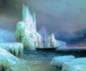
Details of the voyage are described in the two-volume edition, Two-Fold Explorations in the Arctic Ocean and Voyages Around the World in the Years 1819, 20, and 21, carried out on the sloops Vostok and Mirny under the command of Captain Bellingshausen. The sloop Vostok was commanded by Lieutenant Lazarev, who wrote this book. The atlas, published in addition to the book, not only contains maps of the Southern Hemisphere but also vividly depicts the landscapes of the lands and islands discovered during the expedition, as well as natural phenomena and species of plants and animals. The atlas was based on drawings by Pavel Nikolaevich Mikhailov, an academician of painting who specially took part in the round-the-world expedition mentioned in one of the archives of the Ministry of Public Education.
The polar summer was drawing to a close. It was decided that we would move to Australia and continue exploring Antarctica at a later date. In the autumn of 1820, we embarked on the second phase of our Antarctic expedition. Our voyage was a constant battle with the ice, and the events of those days are recorded in the book Russian Navigators: Arctic and Circumnavigation of the World.
The polar summer was coming to an end. They decided to move to Australia and explore Antarctica later. In the autumn of 1820, they started the second phase of expedition. The journey was a constant struggle with the ice, and the events from those days are described in the book Russian Navigators: Arctic and Circumnavigation of the World.
On January 22 (10) 1821, the sailors saw black cliffs on the horizon amidst the snow-covered land. The island was named after Peter the Great, the founder of the Russian Navy. On January 29 (17), they saw land again, but solid ice made it impossible to navigate around it. Bellingshausen therefore mapped the island as a coastline and named it Alexander I Land. Later, it turned out to be the largest Antarctic island, with an area of over forty thousand square kilometers.
The Bellingshausen-Lazarev expedition is rightfully considered one of the most challenging and significant Antarctic expeditions. At the conclusion of his Explorations..., Bellingshausen summarized his discoveries: During our absence, which lasted 751 days, we anchored at 224 different locations, sailed for 527 days, and covered a total distance of 86,475 versts. This space is approximately 2 and 1/4 times the size of the circles on a globe. Throughout our voyage, we discovered 29 islands, including two in the Southern Cold Zone, eight in the Temperate Zone, and 19 in the Hot Zone. Additionally, we found one coral reef with a lagoon.
In addition to geographical discoveries, many valuable astronomical, oceanographic, and ethnographic observations were made during the expedition. Most importantly, however, the first Russian Antarctic expedition confirmed the existence of the legendary South Land.
The news of Antarctica's discovery spread around the world quickly. Numerous articles about the pioneering Russian explorers and the significance of their expedition's findings began to appear on the pages of various publications. The collection Russian Travels also preserves the memory of this historical event. The Presidential Library's portal features a documentary film from 1951 about the Slava flotilla rally in honor of Mikhail Lazarev and Fabian Gottlieb Thaddeus von Bellingshausen, captains of the Russian ships. One can learn more about the discovery of this sixth continent in the collection of Russian round-the-world voyages from the first half of the 19th century.


