| Description |
|
| |
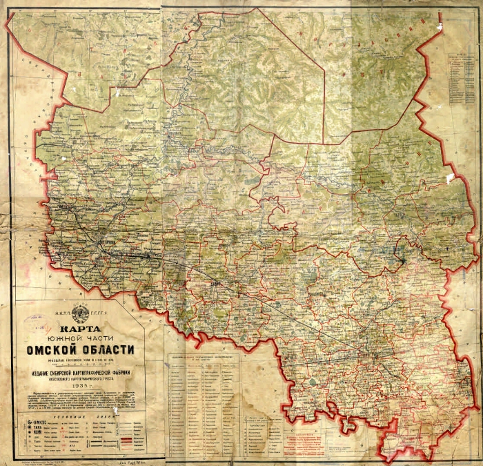
The Omsk Region. Map. 1: 1,000,000. |
|
|
Map of the southern part of the Omsk region [Maps]: compiled in the equally intermediate projection of Professor Krasovsky on the elements of the earth spheroid Bessel / general edition of I. B. Czarniecki, N. A. Rozhkov; technical edition PA Skrynikov; published by IP Dreiling. - 1: 1 000 000, 10 km in 1 cm. - Omsk: publication and printing of the Siberian Cartographic Factory of the All-Union Cartographic Trust, 1935. - 1 card, 2 liters. acc. skl. : color., tab. ; 69x50 (74x54). -
In the overdrive: USSR. NKTP. GGGGU.
The boundaries are plotted according to the data of the Omsk Oblast Executive Committee on March 11, 1935.
Grid in 1 °.
Longitude from [Grinich].
Symbols: For settlements - 7; borders on 11 / III 35 g. - 4; roads - 6; state farms - 3; prom. enterprises - 2; postal and telegraph communication - 2; MTS; oil bases; meteorological stations; marinas - on the 1st.
Table: List of districts subordinate to the Oblast Executive Committee, and their centers.
. - 12,000 copies.
. |
|
I. Skrynikov, P. A. .. II. Dreiling, I. P. .. III. CHernetsky, I.B. IV. Rozhkov, N.A. V. USSR. The main geological-hydro-geodetic control. Omsk region: pages of history (collection). 2. Territory of Russia: Omsk Region (collection). 3. Omsk Region - Geography - Maps. 4. Geographic maps. |
BBK 26.89 (253.3) i64
|
|---|
Source of electronic copy: Omsk GONB
Location on
Omsk GONB |
|